Blog
Design of UAM Network and Ecosystem Integration
Anjan Chakrabarty, Vaishali Hosagrahara and Andrew Lei
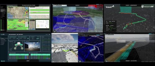
This research delves into the routes and ecosystem partners showcased at CES 2024. It is grounded in the FAA Concepts of Operations for high-density operations in congested airspace. Beginning with vertiport locations identified by Supernal’s city activation group, we devised routes suitable for FAA certification and operation by Supernal’s SA-2 vehicle. These meticulously selected routes underwent evaluation in our high-fidelity simulator to prepare for entry into service.
The operations were overseen by our partner, OneSky, a PSU (Providers of Service for UAM) provider[VH1] , who approved flight plans, offered strategic deconfliction, and monitored conformance. Vertiport management systems (VMS) were provided by our partner, ANRA, whose VMS [VH2] efficiently handled slot reservations for incoming and outgoing traffic.
Additionally, real-time weather updates were supplied by our Weather Partner, TruWeather, while radar data from ground radars deployed in LAX was furnished by Ecodyne. This weather and radar data were seamlessly integrated into our PSU OneSky system, which provided strategic deconfliction.
Our research encompasses the entire ecosystem necessary to scale up UAM for market readiness. Furthermore, our paper includes an analysis of the routes, offering insights into the impact of legacy traffic on the AAM network.
Download the UAM Network paper here.

Figure: AAM Ecosystem: top left TruWeather; Top Middle OneSky PSU with all the routes; top right Viasat comms link along the route; bottom left ANRA Vertiport Management System; bottom middle Supernal sim and OneSky; bottom right Ecodyne and OneSky